Цифровая модель литосферы земли: оценка геодинамических рисков и прогнозирование залежей углеводородов
The earth lithosphere digital model: researches of geodynamic risks and hydrocarbon deposits forecasting
- 1 -
- 2 МГТУ им. Н.Э. Баумана
- 3 Академия ФСИН России
- 4 Академия ГПС МЧС России Москва, ул. Б. Галушкина, 4
- 5 ПАО НК Роснефть
- 6 Уфимский государственный нефтяной технический университет
Рассматривается новая модель литосферы Земли, не имеющая аналогов в мировой практике геофизических исследований. Модель позволяет не только формировать различные запросы к компьютерной базе данных, но и осуществлять различные оценки геодинамических рисков и строить геодинамические индикаторы поиска залежей углеводородов.
The article considers the new digital model of Earth lithosphere having no analogues in the world practice of geophysical studies. The model allows not only to form various queries to computer DB, but also to implement different of geodynamic risk evaluation in a more detailed level and to create geodynamic indicator to search the places of hydrocarbon deposits.
Numerous
scientific studies have found that the changes taking place
in
the Earth lithosphere are the result of various geodeformation
processes occurring in it. Such processes being genetically connected
with dangerous geodynamic phenomena are usually classified according
its "fast" element, into seismic processes (earthquakes)
and according its "slow" element, into current movements of
certain layers and blocks of earth’s crust [1-3].
Quantitative
evaluation of risks connected with these processes, so-called dynamic
risks, is seen as an urgent and crucial problem for the mankind,
as
it directly determines the level of protection for modern
civilization and infrastructures developed from the manifestations of
earth disasters [2, 3].
The development of information systems in the field of geophysical research requires the development of new approaches, standards and instruments for the representation of our knowledge in the field of geodynamic processes.
Furthermore, the developments in the field of geodynamic risks evaluation have lead the authors to one of the most important applied aspect of research, namely, identification of possible locations of hydrocarbon deposits.
Scientific
literature has described current global models of earth crust
–
CRUST 5.1 and CRUST 2.0 [4],
representing the data distributed over the grid with averaging,
correspondingly, of
 and
 ,
containing the information about the velocities of longitudinal and
transverse waves, about the density in earth crust layers including
subcrustal one, as well as about the depths of earth crust division
including Mohorovicic discontinuity (Moho). Model CRUST 1.0. being
developed in 2013 and representing 9 level system of data
representation with averaging over the grid of
 [5]
has fundamental differences.
The information presented in this model allowed the authors to
perform quantitative evaluations of such important distributed
parameters of earth crust as temperature, viscosity, elastic stress
moduli, deformation, and displacement for various deep levels of
earth crust.
Vast
numerical information about the characteristics of lithosphere
geodeformation processes received as a result of the research gave us
the possibility
to solve the problem
of constructing a fundamentally new digital model of Earth
lithosphere including not only the data received from previous
models, but also the characteristics of lithosphere geodeformation
processes calculated by the authors.
In order to construct a digital model of lithosphere as a modern database (DB), the authors have applied online analytical processing technology (OLAP). In this case, the authors prefer hypercubic form of multidimensional data array presentation.
Table
1 shows DB structure
 ,
where Ri
– relations
determined
on the basis of multitude of attributes
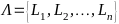 .
Curly brackets specify the areas of
certain attributes determination.
Attributes are characterized by the following dependences:

 (1)
In
this case hypercube is determined as a set of measurements
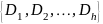 (where Ds
– is a multitude of attribute names) and a multitude
of
attribute names M,
called measures. The values of Ds
are the values of hypercube coordinates values, the values of M
are located in hypercube working space.
DMGRLE
(Digital Model of Geodynamic Risk Lithosphere of the Earth) program
representing the system of sampling and processing the information
from DB lithosphere geodeformation processes characteristics has been
developed to work with the constructed database concerning the
characteristics
of lithosphere
geodeformation processes (with the volume of 1,67 Gb).
The program features such kinds of data manipulation as "Slice", "Page Display", "Slice and Dice", "Rotate, Pivot".
The program represented allows forming various database queries as well as implement different models of geodynamic risk evaluation at a more detailed and qualitative level.
Table 1
DB structure
Attribute designation |
Attribute content |
L1 |
Serial number of a cell |
L2 |
Serial number of a coordinate |
L3 |
Name of a coordinate {longitude, latitude, depth} |
L4 |
Serial number of experimental characteristics of lithosphere geodeformation processes |
L5 |
Name of experimental characteristics of lithosphere geodeformation processes {density, longitudinal wave velocity, transverse wave velocity} |
L6 |
Serial number of estimated characteristics of lithosphere geodeformation processes |
L7 |
Name of estimated characteristics of lithosphere geodeformation processes {pressure, volumetric elastic modulus, shear modulus, temperature, viscosity} |
L8 |
Serial number of normal stress component |
L9 |
Name of normal stress component {x, y, z, r} |
L10 |
Serial number of shear component |
L11 |
Name of shear component {xz, yz, xy, z} |
L12 |
Serial number of displacement vector element |
L13 |
Name of displacement vector element {ux, uy, uz, ur} |
L14 |
Serial number of geodynamic risk type |
L15 |
Name of geodynamic risk type {probabilistic, energy, fuzzy} |
L16 |
Numerical value of attribute parameter |
DMGRLE program provides the implementation of three different models of geodynamic risk evaluation: probabilistic, energy and fuzzy.
Probabilistic model is based on the idea that the sequence of geodynamic states in geological environment represents the events that satisfy the conditions of independence, homogeneity and ordinariness, i.e. they are viewed as simplest threads.
When
we use pk(t)
to designate the possibility that in a certain period
of
time t in
the course of implementing different conditions of geological
environment k
different geodynamic processes can take place, and when we consider
the fact that this possibility depends neither on choosing the timing
system nor on previous state of geological environment, we can
construct the following Kolmogorov differential equations [2, 3]
reflecting three basic states of geological environment –
equilibrium steady state – 1; non-equilibrium unstable state –
2; and quasi-equilibrium state – 3:
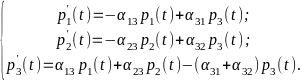 (2)
Coefficients
 (where
 )
reflect energy processes taking place in geoenvironment being the
reason for its transition from state i
into state j.
Probabilistic
model representing the implementation of a new, geophysically
justified approach to coefficient calculation of model ij,
characterizing
the transition of
elementary volume of geological environment between
the
states, allows increasing the efficiency and the adequacy of
geodynamic risk evaluations.
The
purpose of energy model is
to provide the possibility of numeric revaluation of voltage values
after the geological environment of a seismic event has been
implemented in a certain elementary degree. The presence of such
model allows automatic recalculation of field series and generating
new fields
in a database of
lithosphere geodeformation processes characteristics.
Model
of fuzzy geodynamic risk evaluation being
based on a direct fuzzy conclusion as well as on Mamdani algorithm
allows quantitatively evaluating the dynamics of modern lithosphere
geodeformation processes as the values
of
geodynamic risk on the basis of combined analysis of thermal
atmosphere regime, viscous properties of geological sphere substance
in various deep levels and peculiarities in distributing the values
of modern tectonic movements
on the
surface of earth crust which leads, in its turn, to the opportunity
of forecasting geodynamic stability of a certain territory.
An important applied aspect of model studies is the search of geodynamic indicators showing the places of hydrocarbon deposits.
Using
a digital model of Earth lithosphere developed by the authors
this
indicator has been found with respect to known oil and gas basins.
Specifically, in the course of evaluating geodynamic risks for the
territory of Cyprus and its adjacent waters the authors have proved
that forecasted locations
of
oil and gas fields are geographically located at the boundaries of
levorotatory vortex structure formed by specific physical lithosphere
characteristics, this being supported by empirical data for the
observed territory of Cyprus and Mediterranean waters adjacent to it.
So, the article considers a fundamentally new digital model of earth lithosphere having no analogues in the world practice of geophysical studies represented as a computer database of lithosphere geodeformation processes characteristics.
The work with DB of lithosphere geodeformation processes characteristics required the development of specialized program, viz. Digital Model Geodynamic Risk Lithosphere of the Earth (DMGRLE), allowing not only to form various queries to DB, but also to implement different models of geodynamic risk evaluation in a more detailed and qualitative level.
The application of digital model of Earth lithosphere allowed us to find geodynamic indicator to search the places of hydrocarbon deposits.
References
1. Викулин А.В. Физика Земли и геодинамика: учеб. пособие. Петропавловск-Камчатский: КамГУ им. Витуса Беренга, 2008. 463 с.
2. Минаев В.А., Кузьменко Н.А., Фаддеев А.О. Моделирование и оценка геодинамических рисков. М.: изд-во: "РТСофт" "Космоскоп", 2017. 356 с.
3. Минаев В.А., Топольский Н.Г., Фаддеев А.О., Бондарь К.М., Мокшанцев А.В. Геодинамические риски и строительство. Математические модели. М.: Академия ГПС МЧС России, 2017. 208 с.
4. Сеначин В.Н., Баранов А.А. Гравитационные аномалии коры и верхней мантии Центральной и Южной Азии // Geodynamics & Tectonophysics. 2016. Т. 7. № 4. С. 513-528.
5. CRUST 1.0. https://igppweb.ucsd.edu/~gabi/ crust1.html.